Log in
All resources
Create a design
7,171 Free Images of Atlas Map
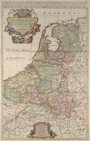
maps from university of amsterdam special collections
atlas der neederlanden
copperplate print
special collections of the university of amsterdam
joan blaeu
copper engraving print
british library
atlas der neederlanden deel v: holland 4. noord-holland
abraham deur
hendrik de leth
gemeente atlas van nederland - south holland
1860s maps of south holland
maps from university of amsterdam special collections
atlas der neederlanden
maps from university of amsterdam special collections
atlas der neederlanden
maps from university of amsterdam special collections
atlas der neederlanden
maps from university of amsterdam special collections
atlas der neederlanden
maps from university of amsterdam special collections
atlas der neederlanden
maps from university of amsterdam special collections
atlas der neederlanden
gemeente atlas van nederland - south holland
1860s maps of south holland
gemeente atlas van nederland - south holland
maps of wassenaar
gemeente atlas van nederland - south holland
1860s maps of south holland
gemeente atlas van nederland - south holland
1860s maps of south holland
nuevo atlas o teatro mundo
old maps of the arctic
atlas minor gerardi mercatoris (1609)
maps of europe by mercator-hondius
old maps of north rhine-westphalia
maps of balve
background
maps
gemeente atlas van nederland - south holland
maps of zuid-beijerland
coats of arms on maps
1645 maps of belgium
atlas ou representation du monde universel t. 2 (1633)
1630s maps of virginia
maps from university of amsterdam special collections
atlas der neederlanden
maps from university of amsterdam special collections
atlas der neederlanden
maps from university of amsterdam special collections
atlas der neederlanden
maps from university of amsterdam special collections
atlas der neederlanden
maps of paris from paris musées
plan de turgot
gemeente atlas van nederland - south holland
maps of zuidland
1878 in switzerland
maps of bremgarten
historisk atlas (stockholm, norstedt & söner, 1880)
maps of 14th-century europe
maps of polders in zeeland
old maps of sluis
maps from university of amsterdam special collections
atlas der neederlanden
maps from university of amsterdam special collections
atlas der neederlanden
maps from university of amsterdam special collections
atlas der neederlanden
maps from university of amsterdam special collections
atlas der neederlanden
maps from university of amsterdam special collections
atlas der neederlanden
maps from university of amsterdam special collections
atlas der neederlanden
maps from university of amsterdam special collections
atlas der neederlanden
maps from university of amsterdam special collections
atlas der neederlanden
maps from university of amsterdam special collections
atlas der neederlanden
maps from university of amsterdam special collections
atlas der neederlanden
maps in the library of congress
1760s maps of china
atlas vingboons
1665
gemeente atlas van nederland - south holland
maps of groot-ammers
atlas ou representation du monde universel t. 2 (1633)
old maps of nuremberg
atlas ou representation du monde universel t. 2 (1633)
maps by hendrik hondius the younger
gemeente atlas van nederland - gelderland
maps of ophemert
petit atlas pittoresque des 48 quartiers de la ville de paris, bhvp
paris former 4e arrondissement
gemeente atlas van nederland - south holland
1860s maps of south holland
media from regionaal archief alkmaar
maps of barsingerhorn
gemeente atlas van nederland - north holland
maps of bussum
gemeente atlas van nederland - south holland
1860s maps of south holland
maps of polders in zeeland
old maps of sluis
maps of polders in zeeland
old maps of sluis
media from regionaal archief alkmaar
maps of barsingerhorn
maps from university of amsterdam special collections
atlas der neederlanden
petit atlas pittoresque des 48 quartiers de la ville de paris, bhvp
paris former 4e arrondissement
atlas des anciens plans de paris by imprimerie nationale, 1880 from bhvp
plan de roussel
maps made in the 17th century
old maps of gelderland
maps of polders in zeeland
old maps of sluis
gemeente atlas van nederland - north holland
blokker
gemeente atlas van nederland - north brabant
maps of putte, netherlands
maps of polders in zeeland
maps of terneuzen
background
maps
maps of utrecht (city) city walls
old maps of utrecht (city)
atlas van der hagen (volume 3)
atlas van der hagen
maps by john cary
1801 maps
maps from university of amsterdam special collections
atlas der neederlanden
maps from university of amsterdam special collections
atlas der neederlanden
maps from university of amsterdam special collections
atlas der neederlanden
historical
history
gemeente atlas van nederland - south holland
maps of spijkenisse
gemeente atlas van nederland - north holland
old maps of haarlem
encyclopédie méthodique - géographie physique
ambroise tardieu
gemeente atlas van nederland - limburg
19th-century maps of maastricht
gemeente atlas van nederland - south holland
old maps of delft
historisk atlas (stockholm, norstedt & söner, 1880)
old maps of the polish-lithuanian commonwealth
background
maps
background
maps
atlas maior, vol 7 (france i) - joan blaeu, 1667 - bl 114.h(star).7
1667 maps
atlas maior, vol 8 (france ii and switzerland) - joan blaeu, 1667 - bl 114.h(star).8
1667 maps
atlas maior, vol 1 (northern europe, norway, and denmark) - joan blaeu, 1667 - bl 114.h(star).1
1667 maps
atlas maior, vol 1 (northern europe, norway, and denmark) - joan blaeu, 1667 - bl 114.h(star).1
1667 maps
maps from university of amsterdam special collections
atlas der neederlanden
historisk atlas (stockholm, norstedt & söner, 1880)
maps of 13th-century germany
gemeente atlas van nederland - north holland
old maps of alkmaar
maps of the west-indische compagnie
old maps of dutch brazil
topographischer atlas der schweiz
maps of lake lugano
encyclopédie méthodique - géographie physique
ambroise tardieu
gemeente atlas van nederland - south holland
1860s maps of south holland
atlas maior, vol 3 (germany) - joan blaeu, 1667 - bl 114.h(star).3
copper engraving print
atlas maior, vol 3 (germany) - joan blaeu, 1667 - bl 114.h(star).3
copper engraving print
atlas maior, vol 4 (netherlands) - joan blaeu, 1667 - bl 114.h(star).4
copper engraving print
atlas maior, vol 3 (germany) - joan blaeu, 1667 - bl 114.h(star).3
copper engraving print
atlas maior, vol 3 (germany) - joan blaeu, 1667 - bl 114.h(star).3
copper engraving print
atlas maior, vol 3 (germany) - joan blaeu, 1667 - bl 114.h(star).3
copper engraving print
atlas maior, vol 4 (netherlands) - joan blaeu, 1667 - bl 114.h(star).4
copper engraving print
atlas maior, vol 4 (netherlands) - joan blaeu, 1667 - bl 114.h(star).4
copper engraving print
old maps of gelderland
atlas van loon
atlas maior, vol 4 (netherlands) - joan blaeu, 1667 - bl 114.h(star).4
1667 maps
atlas maior, vol 2 (sweden, russia, poland, eastern europe, and greece) - joan blaeu, 1667 - bl 114.h(star).2
17th-century maps of the aegean sea
atlas maior, vol 1 (northern europe, norway, and denmark) - joan blaeu, 1667 - bl 114.h(star).1
1667 maps
atlas maior, vol 2 (sweden, russia, poland, eastern europe, and greece) - joan blaeu, 1667 - bl 114.h(star).2
17th-century maps of poland
atlas maior, vol 1 (northern europe, norway, and denmark) - joan blaeu, 1667 - bl 114.h(star).1
1667 maps
2601 - 2700 of 7,171
Next page
/ 72


![Kennemerland Water Board Map - Rijnland Water Board, Hendrik de Leth, [1729]](https://cdn.creazilla.com/illustrations/10000405711/kennemerland-water-board-map-rijnland-water-board-hendrik-de-leth-1729-md.jpg)
![Kennemerland Water Board Map - Rijnland Water Board, Hendrik de Leth, [1729]](https://cdn.creazilla.com/illustrations/10001040533/kennemerland-water-board-map-rijnland-water-board-hendrik-de-leth-1729-md.jpg)
![Kennemerland Water Board Map - Rijnland Water Board, Hendrik de Leth, [1729]](https://cdn.creazilla.com/illustrations/10001090722/kennemerland-water-board-map-rijnland-water-board-hendrik-de-leth-1729-md.jpg)
![Kennemerland Water Board Map - Rijnland Water Board, Hendrik de Leth, [1729]](https://cdn.creazilla.com/illustrations/10000761895/kennemerland-water-board-map-rijnland-water-board-hendrik-de-leth-1729-md.jpg)
![Kennemerland Water Board Map - Rijnland Water Board, Hendrik de Leth, [1729]](https://cdn.creazilla.com/illustrations/10001356914/kennemerland-water-board-map-rijnland-water-board-hendrik-de-leth-1729-md.jpg)
![Kennemerland Water Board Map - Rijnland Water Board, Hendrik de Leth, [1729]](https://cdn.creazilla.com/illustrations/10001321586/kennemerland-water-board-map-rijnland-water-board-hendrik-de-leth-1729-md.jpg)


![Gerardi Mercatoris and I. Hondii Atlas or Representation of the Universal World, and of the Parts of It, Made in Tables and Very Ample Descriptions. [t. 2].](https://cdn.creazilla.com/illustrations/10001569396/gerardi-mercatoris-and-i-hondii-atlas-or-representation-of-the-universal-world-and-of-the-parts-of-it-made-in-tables-and-very-ample-descriptions-t-2-sm.webp)
![Kennemerland Water Board Map - Rijnland Water Board, Hendrik de Leth, [1729]](https://cdn.creazilla.com/illustrations/10000578202/kennemerland-water-board-map-rijnland-water-board-hendrik-de-leth-1729-md.jpg)
![Kennemerland Water Board Map - Rijnland Water Board, Hendrik de Leth, [1729]](https://cdn.creazilla.com/illustrations/10001117580/kennemerland-water-board-map-rijnland-water-board-hendrik-de-leth-1729-md.jpg)
![Kennemerland Water Board Map - Rijnland Water Board, Hendrik de Leth, [1729]](https://cdn.creazilla.com/illustrations/10001059183/kennemerland-water-board-map-rijnland-water-board-hendrik-de-leth-1729-md.jpg)
![Kennemerland Water Board Map - Rijnland Water Board, Hendrik de Leth, [1729]](https://cdn.creazilla.com/illustrations/10001456497/kennemerland-water-board-map-rijnland-water-board-hendrik-de-leth-1729-md.jpg)


![Kennemerland Water Board Map - Rijnland Water Board, Hendrik de Leth, [1729]](https://cdn.creazilla.com/illustrations/10000704117/kennemerland-water-board-map-rijnland-water-board-hendrik-de-leth-1729-md.jpg)
![Kennemerland Water Board Map - Rijnland Water Board, Hendrik de Leth, [1729]](https://cdn.creazilla.com/illustrations/10000534022/kennemerland-water-board-map-rijnland-water-board-hendrik-de-leth-1729-md.jpg)
![Kennemerland Water Board Map - Rijnland Water Board, Hendrik de Leth, [1729]](https://cdn.creazilla.com/illustrations/10000978808/kennemerland-water-board-map-rijnland-water-board-hendrik-de-leth-1729-md.jpg)
![Kennemerland Water Board Map - Rijnland Water Board, Hendrik de Leth, [1729]](https://cdn.creazilla.com/illustrations/10001181332/kennemerland-water-board-map-rijnland-water-board-hendrik-de-leth-1729-md.jpg)
![Kennemerland Water Board Map - Rijnland Water Board, Hendrik de Leth, [1729]](https://cdn.creazilla.com/illustrations/10001035907/kennemerland-water-board-map-rijnland-water-board-hendrik-de-leth-1729-md.jpg)
![Kennemerland Water Board Map - Rijnland Water Board, Hendrik de Leth, [1729]](https://cdn.creazilla.com/illustrations/10001510543/kennemerland-water-board-map-rijnland-water-board-hendrik-de-leth-1729-md.jpg)


![Gerardi Mercatoris and I. Hondii Atlas or Representation of the Universal World, and of the Parts of It, Made in Tables and Very Ample Descriptions. [t. 2].](https://cdn.creazilla.com/illustrations/10001133003/gerardi-mercatoris-and-i-hondii-atlas-or-representation-of-the-universal-world-and-of-the-parts-of-it-made-in-tables-and-very-ample-descriptions-t-2-sm.webp)
![Gerardi Mercatoris and I. Hondii Atlas or Representation of the Universal World, and of the Parts of It, Made in Tables and Very Ample Descriptions. [t. 2].](https://cdn.creazilla.com/illustrations/10000421870/gerardi-mercatoris-and-i-hondii-atlas-or-representation-of-the-universal-world-and-of-the-parts-of-it-made-in-tables-and-very-ample-descriptions-t-2-md.jpg)


![Stadsprofiel van] NAPOLI, 1704](https://cdn.creazilla.com/illustrations/10000682766/stadsprofiel-van-napoli-1704-md.jpeg)


![Map of the polder of Oost Voorn / Heyman van Dyck fecit 1695; A. Steyaart invented; I. Stemmer's sculpsit; I. Shutters fecit cum aqua forti, Romeyn de Hooghe, [1701]](https://cdn.creazilla.com/illustrations/10000729215/map-of-the-polder-of-oost-voorn-heyman-van-dyck-fecit-1695-a-steyaart-invented-i-stemmers-sculpsit-i-shutters-fecit-cum-aqua-forti-romeyn-de-hooghe-1701-md.jpg)


